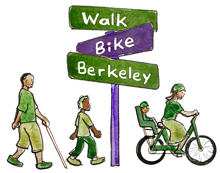
Hopkins Street: Support Safety and Mobility Choices for All!

Berkeley’s City Council has approved an exciting plan to bring safety and mobility choices to all along eastern Hopkins Street and must also decide whether to extend it to western Hopkins.
UPDATE: As of April 4, 2023, the City has indefinitely postponed this nearly final project, citing staff shortages. We are deeply disappointed in the City’s decision to postpone critical pedestrian and bicycle safety improvements on Hopkins, and we’re calling on the City to get the project back on track quickly:
Our April 5th statement in response to the delay
Our point-by-point responses to the City Manager’s memo
We (still) need your help to make sure City Council stays committed on the eastern segment and extends the project to the western end of Hopkins. We are calling on City Council and the City Manager to get this project back on track quickly. We cannot keep delaying and postponing critical safety improvements, like this project, when people face these dangerous streets every day.
At least ten of our city’s Council-approved policies, plans, and referrals support making ALL of Hopkins safe for people walking and biking. It’s a safe route to school for children at four schools, including our largest middle school. It’s also a critical east-west connector between the wonderful amenities in the Hopkins/Monterey area and those living in historically-disinvested west Berkeley. The plan protects our sidewalks for pedestrians and vulnerable residents by providing a safe place off the sidewalk for those who can ride bikes, scooters and other micromobility devices.
How can I help?
The Mayor and City Council need to hear your support for these exciting safety and access improvements. Here are ways to share your thoughts:
Comment at the City Council meeting on April 18. Sign up to share your interest in speaking when the plan is finally taken to Council. We’ll help you prepare and send you a notification!
Email the Mayor and City Council at: council@cityofberkeley.info and ask them to get this project back on track.
So what’s the plan?
We know many are curious about what’s being planned, so here’s an overview.
Transit Improvements
Our city has a transit-first policy, and it shows in these plans! The transit improvements, including bus boarding islands on the south side for the segment from The Alameda to Gilman where the 12 bus runs, will help keep the bus moving on schedule and provide safe places for people to board and exit the bus. They also include sidewalk-level crosswalks from the bus boarding islands across the two-way bike/micromobility lanes to get people safely to and from the bus.

Bus boarding islands with crosswalks across the bike/micromobility lanes provide safe spaces to get on and off the bus and cross over to the sidewalk.
Traffic Calming
Our city has adopted a Vision Zero plan to eliminate severe injuries and deaths from traffic violence. To achieve this goal the plan puts engineering strategies first. We must redesign our streets to slow traffic, making them safer for everyone. The Hopkins project incorporates these types of changes, including narrower car travel lanes, raised crosswalks, crossing medians and bulb-outs (sidewalk extensions to increase pedestrian visibility, slow turning cars, and shorten crossing distances for pedestrians).

Bulb-outs increase pedestrian visibility, slow turning cars, and shorten crossing distances for pedestrians.

Raised crosswalks slow moving vehicles and clearly identify a space prioritized for pedestrians.
Daylighting Intersections
These Vision Zero changes also include painting red curbs near intersections to make it easier for everyone to see each other, whether driving, riding or walking.

Protected Two-way Bike/Micromobility Lanes
Along the entire length of Hopkins Street, two-way bike/micromobility lanes would be installed on the south side of the street. These will provide protected access from east to west across north Berkeley for people riding bikes, scooters, and assistive mobility devices like modified bikes and powered wheelchairs. They will also provide safe routes to school for children and families to four schools (King Middle, Ruth Acty, Crowden, and St. Mary’s College HS), as well as various preschools. And, as an important benefit, studies show consistently that adding protected bike/micromobility lanes increases safety for all road users, whether walking, riding, or driving. Studies also show that these types of bike/micromobility lanes help businesses thrive by bringing more customers to shops and restaurants more frequently.

See more on the city’s web page:
Kains to Gilman: City staff have proposed three options, which we’re expecting City Council to consider on April 18, 2023. Option 3, extending the improvements all the way to Kains, is the option we need for our low-stress network.
Gilman to The Alameda: Council adopted this conceptual design with minor amendments, except for the segment from The Alameda to Sutter, which was changed during the council meeting. Approved May 2022.
The Alameda to Sutter: Council directed staff to continue the two-way protected bike/micromobility lanes along the south side of Hopkins for this segment. Approved May 2022.
When will this be built if it’s approved?
This year! The improvements are scheduled to be made when Hopkins Street is repaved this year (2023). However, if Council votes to revisit the approved portion (eastern segment) or proposes a plan for the western segment other than one of the three options presented by City staff, the implementation will be delayed with an unknown timeline. We can’t afford to wait!
Why does Walk Bike Berkeley support the plan?
This project has been in progress for over six years, starting with the decision to include Hopkins Street as an important east-west connector in the Bicycle Plan in 2017. There are many details about how we’ve arrived where we are today on Hopkins, including how and why decisions were made. Here is some additional information for those who would like to know more.
Advances Our Community’s Priorities and Goals
As mentioned earlier, our city has been working for over a decade to address climate change and improve safety on our streets. At least ten of Berkeley’s city’s Council-approved policies, plans, & referrals support making Hopkins safe for people walking and biking.
As we build more housing, we need to offer more mobility options
Due to the housing crisis and our responsibility as a community to provide enough housing for all, we are now allowing housing to be built without parking, such as backyard cottages. The expectation is not that people moving into these new homes will park in the street, but rather, it’s that they will use other mobility options, like taking transit or riding a bike or scooter. But for them to make that choice, we need to improve transit and importantly, build a full bike/micromobility network that is safe, convenient and comfortable for users of all ages and abilities.
implements our Bicycle Plan
In 2017, our City Council unanimously approved a progressive and exciting Bike Plan to create a low-stress bikeway network across the City for people of all ages and abilities to be able to safely, comfortably and conveniently ride their bike, scooter, or other micromobility device. It critically calls for a complete network, to get people safely from door to door across our city.
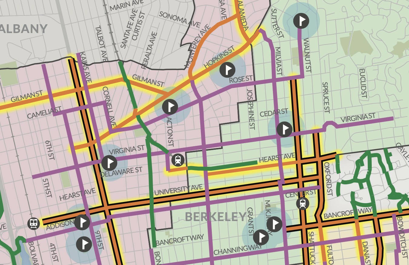
This map shows Hopkins as part of Berkeley’s low-stress bikeway network recommended in the 2017 Bicycle Plan. The flag icons show the location of public schools. The full map with legend is available on page ES-16 of the Bicycle Plan here.
Making ALL of Hopkins safe is important
Key East-West Connection. Take a look at a map of west Berkeley and you will see that the street network in northwest Berkeley does not follow the grid further south. For those living north of Cedar Street and west of the Ohlone Greenway, there are only four east-west connections: Gilman St., Hopkins St., Rose St. and Cedar St, all of which are heavily used by cars and trucks. There are no other direct connections. Critically, Hopkins connects directly to Gilman St, advancing our low-stress bikeway network. In addition, it is the most direct route to the schools and amenities on Hopkins St., and it has the lowest and easiest grade change, making it the best route choice for people of all ages and abilities.
Safe Routes to School: Hopkins is a key safe route to school for children at Ruth Acty Elementary, King Middle, Crowden, and St. Mary’s High, as well as various preschools. With the new middle school redistricting, Hopkins is a Safe Route to School for all King students who live west of San Pablo to get to middle school.
Equity access for West Berkeleyans: Due to historic disinvestment, people living in District 1 in northwest Berkeley, west of the Ohlone Greenway, lack amenities such as a middle school, an elementary school, a track and a pool. Those amenities along Hopkins Street are the closest for much of District 1 and are located at an ideal distance for people who can ride their bike or other micromobility device. And with the recent redistricting, King Middle School is the middle school for all students in West Berkeley, north and south, who are the perfect age to be gaining independence by riding their bikes and scooters to school. But it’s currently not safe to make that choice. The western end of Hopkins from Kains to Monterey/California is the gateway to these wonderful amenities but currently very unsafe to ride. (Please take a moment to read Councilmember Taplin’s moving story.)
The “Ada Bypass” doesn’t work. Some have proposed that Ada Street would work as an alternate, but after considering the option early in the process, City staff decided against recommending it because it only runs for four blocks and does not meet the City’s goals for a network for all ages and abilities. Read more here.
Extending protected bike/micromobility lanes to Kains makes sense. The Alameda County Transportation Commission (ACTC) is nearing the implementation phase of a multi-year project along San Pablo Ave. As part of the phase 1 implementation, they are turning Kains into a bike boulevard from Virginia St. all the way into Albany. The Hopkins Street bike/micromobility lanes, if extended, will connect to this new bike boulevard. With a new pedestrian and bike crossing light coming soon at Camelia/San Pablo Ave., a Hopkins-Kains-Camelia connection will help folks get across San Pablo and to the new I-80/Gilman pedestrian and bike bridge to get to the sports fields and the Bay Trail.
Protected bike/micromobility lanes are the only way to make Hopkins safe for all ages and abilities
Our city’s bike plan set a goal of a low-stress network for people of all ages and abilities. This is what is needed to help people who are able, to make the choice to use bikes or other micromobility devices rather than drive. To make a corridor low-stress, there are two main options. 1. Limit traffic volume and speed on a continuous route that is parallel to a busy street; or 2. Provide protection from higher traffic volumes and speed. Most of the city’s bike boulevard network was accomplished using the first option, typically installing traffic diverters to limit through-traffic and speed humps and traffic circles to calm traffic. Ideally, cities will employ both methods to provide maximum connectivity and safe options. However, in certain places, like Hopkins, there is no parallel route that can be selected where traffic volume can be limited. Therefore, protected lanes are needed.
Other treatments, like sharrows (the stencils seen on bike boulevard streets), and painted bike lanes do not physically separate people on bikes from vehicles and thus do not provide the safety needed to be low-stress for people of all ages and abilities on higher traffic-volume streets like Hopkins.
Two-way bike/micromobility lanes were a reasonable compromise to preserve parking east of McGee
As part of the study for the eastern segment of Hopkins (Sutter to Gilman), the City considered both two-way protected bike/micromobility lanes and a single protected lane on each side. From The Alameda to McGee, which runs along the track and park, parking on one side of the street would have to be removed to have a single lane on each side of the street. However, parking could be kept on both sides of the street for this stretch if a two-way lane was chosen, and if the bike and parking lanes were squeezed to a bare minimum. Contrary to the wishes of many who have been advocating for protected bike/micromobility lanes, the City chose the two-way option primarily to retain parking on both sides of the street from McGee to Josephine. That said, we’re still delighted to have protected bike/micromobility lanes in any form, as they’re all much safer than any of the unprotected options, like standard bike lanes or sharrows, which provide no protection at all.
Good for people of all Ages and Abilities
We need to make Berkeley safer so people of all ages and abilities can choose to walk, bike or use mobility devices to get around. People who ride bikes are often stereotyped as younger, athletic people. The stereotypes are wrong—and dangerous. Organizations like AARP support projects like this with active transportation, bike facilities and complete streets as key components of livable communities for people of all ages and abilities. In addition, building protected bike/micromobility lanes helps protect our sidewalks for our most vulnerable residents by giving people riding bikes and scooters a safe place to ride OFF the sidewalk. Finally, protected bike/micromobility lanes can also be a safe and smooth place for users of electric-powered wheelchairs and other assistive devices. And working to make the project inclusive of all abilities, our City engineers can use the principles of Universal Design to design inclusive protected bike/micromobility lanes that won’t compromise safety for anyone.

Protected bike/micromobility lanes can be helpful for people of all ages and abilities.
good for business
When cities make commercial areas more walkable and bikeable, studies show that it has either positive or no impact on businesses. Unfortunately, business owners often overestimate customers’ car trips and underestimate the economic benefits of other travel modes. While people walking and biking may spend less per trip than motorists, they make more frequent trips and thus spend more overall. In addition, people on foot and bike enliven the street, promoting social interaction, and making commercial areas more pleasant.
So, let’s talk about parking
Rebalancing our public space: All parking changes in this project involve public space owned by the entire community, but which is currently occupied by free on-street parking. Currently, on most of Hopkins, ALL of that space, from curb to curb, is used for the benefit of people driving, both while they’re in motion or to store their cars when they are not in motion. None of it is used to provide safe access to people riding bikes, scooters, or powered micromobility devices. This project rebalances the street to provide some space for people using active transportation, while still keeping the majority of street space for people driving.
Shops near Hopkins/California: The majority of parking used by patrons is being retained, including the parking along California, Ada, and McGee. In addition, the City will use best practices learned from its highly successful GoBerkeley parking program to introduce parking management to the area. Parking management strategies, such as metered and time-limited parking, help to increase turn over of parking to increase parking availability.
Section by section impacts:
Sutter to McGee: On-street parking is mostly retained on both sides of the street, except for spots being removed for safety to daylight intersections (see above.)
McGee to California/Monterey: On-street parking is retained in front of the shops on the south side of the street, except for one spot being removed for safety to add a stop sign at the McGee/Hopkins intersection. Parking is removed on the north side of the street to provide enough space for the protected bike/micromobility lanes.
California/Monterey to Gilman: On-street parking is removed on both sides of the street due to a narrower road to provide enough space for the protected bike/micromobility lanes. Almost all houses have off-street parking on this stretch.
Gilman to Northside: On-street parking is removed on both sides of the street due to a narrower road to provide enough space for the protected bike/micromobility lanes. Almost all houses have off-street parking on this stretch.
Northside to Kains: On-street parking is mostly retained on the north side of the street, except for the block from Cornell to Curtis and the spots being removed for safety to daylight intersections. Parking is removed on the south side of the street to provide enough space for the protected bike/micromobility lanes. Almost all houses have off-street parking on this stretch.
Prioritizing available parking: Once the safety improvements are made, the remaining free on-street parking in the area can be assessed and adjusted to reflect our community’s values. For instance, we can add blue curbs to the closest spaces at cross streets to prioritize people with disabilities or other mobility challenges. The spaces are often as close as accessible spaces at a typical store. We might also add green curbs (5-15 minute parking) to the next closest spaces to provide spaces for our delivery drivers and those using app-based delivery services. And then, yes, some who are more able will have to walk further to get to their parked cars. But importantly, they will still have safe access to do so, even if they are farther away. This seems a reasonable and safe ask to increase safety and access for people who currently have none.
It’s time to move this project forward
Hopkins is scheduled to be repaved in 2023. City policy says that planned improvements, such as those in the Pedestrian Plan and Bike Plan should be done at the same time, both for fiscal responsibility and to speed the implementation of these plans. The paving plan and the bike plan have been laying out these improvements for years. Plus there has been additional public process over the past three years for various parts of the project. It’s time to get it done, both to provide relief for people currently braving our dangerous streets to do their part for climate action and also to open up that possibility to those who are currently too afraid.
Status and Schedule
Hopkins Eastern Segment, Sutter to Gilman: Approved by City Council in May 2022. Engineering drawings are almost complete. However, some community members are pressuring Council to revoke the May 2022 approval. So, we’re asking Council to stand strong and implement the approved plans.
Hopkins Western Segment, Gilman to Kains: Going to City Council in April 2023. We’re asking Council to extend the safety and access improvements to west Berkeley, all the way to Kains.
Construction should start in 2023: All approved designs are scheduled to be included with the repaving to start this year (2023). However, if Council votes to revisit the approved portion (eastern segment) or proposes a plan for the western segment other than one of the three options presented by City staff, the implementation will be delayed, costing additional money and preventing City staff from being able to move their focus to other much-needed projects, especially in equity-priority areas. We can’t afford to wait!
How Can I Help?
The Mayor and City Council need to hear your support for these exciting safety and access improvements. Here are ways to share your thoughts:
Comment at the City Council meeting on April 18. We expect it to be held virtually and in person at 6pm at 1231 Addison St., Berkeley. Sign up here to let us know you’re interested in speaking, and we’ll help you prepare and send you a notification!
Email the Mayor and City Council at: council@cityofberkeley.info. Feel free to keep it brief. We recommend making sure to state clearly that you support making the previously-approved safety improvements on the eastern segment of Hopkins (Sutter to Gilman) and extending them west all the way to Kains. And if you can, add at least one reason why that’s important to you.
Any one of these would be tremendously helpful given the resistance by those who are satisfied with the status quo. And if you’re so inclined, go for all of the above! Council needs to hear loud and clear that people’s safety and equitable access are our top priorities!
Suggested Talking Points
Customized letters are more effective than form letters. Here are some options if you would like some help getting started. We recommend selecting just one or two.
We cannot continue to delay critical safety improvements to our streets and neighborhoods. Please get this project back on track quickly.
We need safety and mobility choices now, for our children, for our elders, for all of us.
Please hold firm on your powerful decision to bring safety to the eastern end of Hopkins, and vote to extend the improvements and access to West Berkeley by extending the project all the way to Kains.
There are four schools within two blocks of the most-contested area of this plan. If we preserve parking instead of installing safety improvements, and a student or anyone else is seriously injured or killed riding a bike to one of these schools, will the council feel it made the right choice?
Berkeley cannot fulfill its Climate Action Plan, Vision Zero Action Plan, Bicycle Plan, or Pedestrian Plan (see https://berkeleyca.gov/your-government/our-work/adopted-plans) without removing some parking spaces. There is no way to meet these goals and keep all the parking everyone has today. Transportation is the single largest contributor to Berkeley’s greenhouse gas emissions and acting to provide safe alternate options to reduce private car transportation is by far the fastest route to address this.
The opposition to this project focuses on bike lanes as though they only benefit people riding bikes. Complete Streets, including protected bike lanes, benefit all road users and prevent injuries and deaths for people walking, riding bikes and driving. Our goal should not be bike lanes but street safety, and protected bike lanes are one great tool to achieve that.
The merchants concerned about the loss of parking are not arguing from data. Again and again, merchants object to bike lanes and then wind up benefiting from them. Many more people can come to stores and park in bike racks than can come in cars and park on the street—often as many as 10 bikes per parking space. We should not cancel bike lanes based on fears, when the data show that the results will help these merchants rather than hurting them.